Some events are proofs of Murphy's law, or its many corollaries.
Tom H has been leading rides this season to hit the highest points in every county in NJ. The ride this weekend was to those in Morris, Passaic, and Bergen (the order in which we did them). Tom was honest in saying that this ride might "suck" (his term) because he hadn't been on these roads before, and didn't know their condition; he was going off the reports from Dustin Farnum's NJ Bike Map site. He said he hoped they wouldn't be too busy. He warned us that it would be a hilly ride; not many steep hills (more later), but there was very little flat.
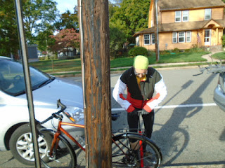
The start was at Pompton Lakes Middles School, an hour away (or more) by car for those of us on the ride. We split into car pools; I rode up with Snakehead and his coworker John. John is a runner, but hasn't been on a ride this long since his teens, decades ago. (I was predicting dire things for John in my head, but he defied my dire predictions and did well.) When we got to the school, the parkiing lot had traffic cones, so we street-parked. Unpacking and setting up:
Above, John; below, Snakehead.
Jack came alone. Laura and Marco came together.
Below, Tom, the founder of the feast.
There was a sharp hill right at the start, and, on it, I had a recurrence of my brake bind from the previous day; I stopped to adjust the brake, but couldn't get started on the bike again and had to walk up the steep part of the hill. It wouldn't be the last time on this ride.
We continued; there was another steep spot... this time I had a brake bind on the other side. I opened the brake and decided to fix it at the stop. And walked up the steep part of the hill. (Hrmph.)
Roads had more traffic on them than we expected; they also largely did NOT have shoulders. The Excellent Wife (TEW) and I had been to visit a friend south of Philadelphia the day, and the traffic was heavy and anxiety-inducing both ways; I felt the anxiety return every time I looked in my mirrors and saw a parade of cars lining up behind us. (The mechanical problems with the bike didn't help.)
Off we went. We had to cross Rte 23, and to do so, we had to ride along it for a short way and cross at a jughandle. I did my usual Salve Regina chant, and we got across without incident. (I'm not claiming a cause-and-effect relationship, but there is, so far, a 100% correlation.)
We got to the high point of Morris, which was partway up a road to a higher crest (the road crosses the border between the counties). This road also had a steep part. I wound up dropping chains both outside and inside the cranks... and walked the bike up the steep part. I did a quick tighten of the limit screws, which has
solved the problem, but I'm glad there wasn't any Xanax at the
roadside, I would have been chomping them like M&M's.
(OK;
I can see the chain drops on the outside after the recent rebuild; I
changed the large ring. But why was the chain dropping to the inside? It's
a mystery to me.)
Tom got his pictures of us, and I got my picture of Tom getting his picture of us.
We went back down and stopped at a deli, where Snakehead and I shared a sandwich, and I did some mechanical adjustments, and got some pics of the folks and the foliage.
Stopping for more pictures:
The Passaic high point is along another busy, no-shoulder road, at a bar-and-deli. Below, my pics:
We didn't stop there for a break; Tom said there was a bagel place further on that would make a better stop... but miles went by and we didn't see it. Instead, we stopped at a bar-and-deli (interesting combination!) we saw along the way.
I loved the juxtaposition of the two sets of bikes: the bar patrons' motorcycles, and ours, pedal-powered.
And about a half-mile later, there was the bagel place.
Then up to the Bergen high point. We climbed and climbed, traffic backing up behind us and passing when it could, with varying amounts of clearance space. At one point, Tom said there would be about 200 more feet of climb; it turned out to be more like 400 feet, and some of our number were shot; I got caught behind someone, and twice I was going so slowly that the GPS stopped registering forward motion. Only one pic at the top; the others didn't come out, perhaps because I was shaking so hard!
Tom said from there, it was all downhill, and it very nearly was: of the six miles remaining to the start, probably five miles was descent. At the bottom, some of us got more foliage pics.
It was a beautiful day for a ride, but it was difficult and anxiety-producing for me. I'm glad I went... but I'm glad I don't have to do it again.


No comments:
Post a Comment